Google-Earth
Featured Article
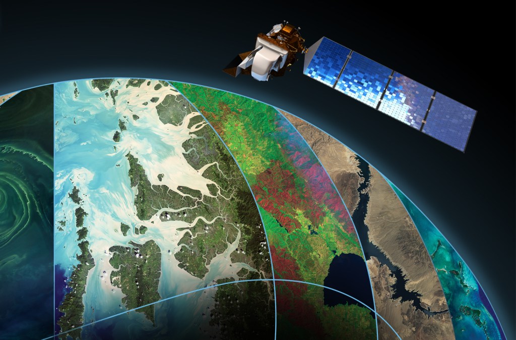
After 50 years pioneering satellite imagery, NASA’s Landsat is ready for 50 more
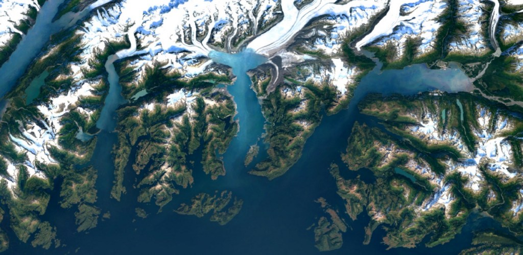
NASA’s Landsat satellites have consistently made history in Earth observation since the project’s first launch in 1972, with this year marking 50 years of innovation and science. Its influence may surprise you, as will its continued relevance in the face of a fast-growing commercial imaging satellite sector. Landsat may be a familiar name to you…
Google Maps’ Street View celebrates 15 years with historical imagery on mobile, new camera and more
Google Maps’ Street View feature was created 15 years ago, and since then, has added more than 220 billion Street View images from over 100 countries and territories. Many of…

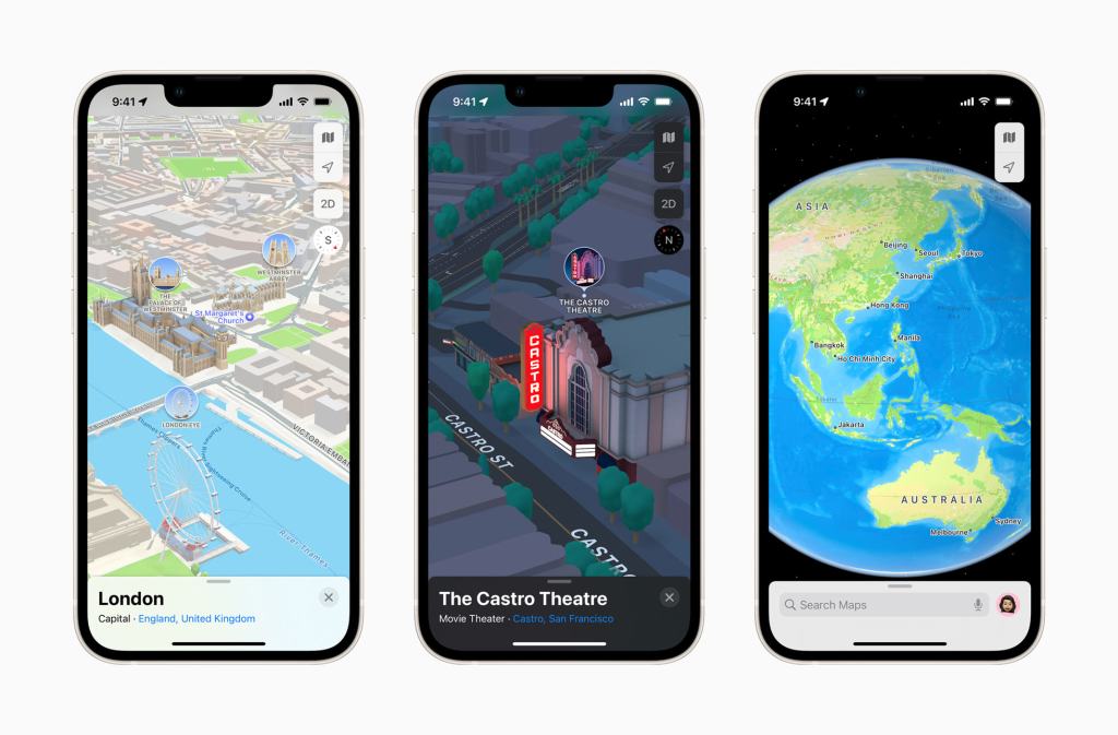
Apple Maps rolls out 3D view to London, LA, New York and San Francisco
Apple is bringing its 3D maps to more cities within the Apple Maps app, including London, LA, New York and San Francisco. The experience, launching with iOS 15, follows several…
Daily Crunch: Google Earth gets an update
Google Earth gives users a new look at a changing planet, Facebook tests new business discovery features and Autodesk acquires Upchain. This is your Daily Crunch for April 15, 2021.…
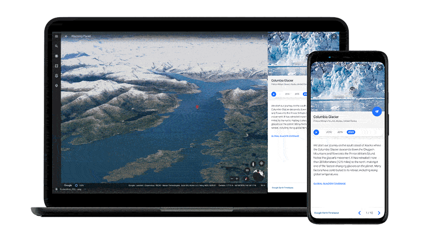
Google says Google Earth is getting its biggest update since 2017
Google Earth now features a time-lapse mode that brings together 24 million satellite photos from the last 37 years. And… that’s it. Google says it’s the biggest update to Google…
NASA and Planet expand imagery partnership to all NASA-funded Earth science research
NASA and Planet have deemed their pilot partnership a success, and the result is that NASA will extend its contract with Planet to provide the company’s satellite imagery of Earth…

Anyone can now create maps and stories on Google Earth
Google Earth is making a significant change to its product, with the addition of content creation tools that allow anyone to create maps and stories for its platform. The feature…

Carmen Sandiego returns to Google Earth with a new caper
Google Earth first made use of its rich global 3D visualization as a backdrop for a Carmen Sandiego tie-in back in March, but today there’s a new adventure to explore.…

Aclima sucks in $24M to scale its air quality mapping platform
Aclima, a San Francisco-based company which builds Internet-connected air quality sensors and runs a software platform to analyze the extracted intel, has closed a $24 million Series A to grow…
Google Earth now lets you measure distances and areas
Only a few years ago, Google Earth was the only practical way to see all of Google’s satellite and 3D imagery. These days, Google Maps pretty much offers all of…
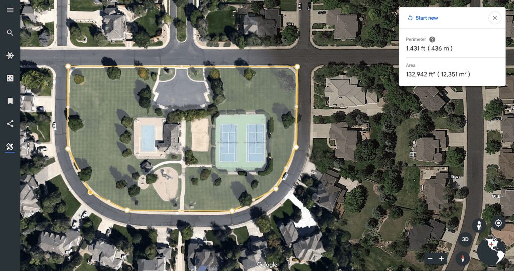
In April, Google unveiled a new vision for its Google Earth application, two years in the making, that introduced more ways to explore the planet through guided tours, informational cards,…
Google Earth comes to the classroom with new educational tours and lesson plans
In April, Google introduced a revamped, reimagined version of Google Earth, which included a number of new features that go beyond visualizing the planet through the use of maps and…
Google Earth for Chrome & Android gets upgraded with guided tours, more discovery features
As reported earlier this month, Google today has unveiled its new vision for Google Earth, the software that combines satellite imagery, topographic maps and 3D cities, to help you better visualize…
Google Earth Enterprise, which originally launched over ten years ago, was Google’s tool for businesses that wanted to build and host private versions of Google Earth and Google Maps for their…
Google may have just launched its major consumer virtual reality effort, Google Daydream, last week, but the company is showing no signs of slowing development on other platforms as it…

Google shuts down Panoramio
Panoramio, the location-centric photo sharing service Google acquired in 2007, will show its last image on November 4. For the longest time, Google used Panoramio to augment its Google Maps and Google Earth…

Google updates Classroom with new tools for students, parents and teachers
Google Classroom, the company’s platform that brings together Google Apps for Education and a number of tools for managing classes and content, is getting one of its regular summer updates…

Google Earth and Maps get sharper satellite imagery with new update
Several years ago, Google engineers figured out a way to stitch together satellite imagery to remove clouds, giving Google Earth and Google Maps users a better and more comprehensive view…
Astro Digital Releases Platform For Anyone To Analyze Satellite Imagery
Astro Digital, a satellite imaging and imagery analysis company, released the newest version of their image processing software today. Anyone can access their software, for free, and retrieve satellite imagery of any…

How Google’s Networking Infrastructure Has Evolved Over The Last 10 Years
Google today announced that it wants to fix your home Wi-Fi, but internally, it has long been working on far more complex networking issues. To connect the hundreds of thousands…

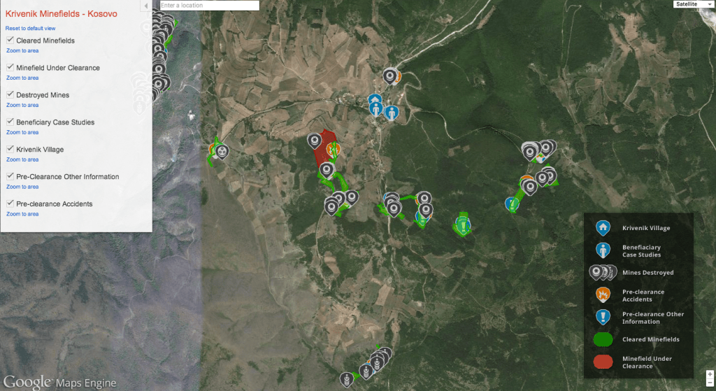
Google’s Maps For Business A Key Ingredient For HALO Trust’s Mine Clearing Efforts In Kosovo
Google’s Maps and Earth products are a good way to pass some idle time, zooming around the globe, but they’re also tools that can be put to use in scenarios…
Google Maps Gets New And Updated 3D Imagery For 50 U.S. Cities
Google today announced one of its largest updates to Google Maps’ 3D imagery since it launched last year. The service now covers a number of additional cities that weren’t included…

Google Launches Google Earth Pro 7.1 With New Viewshed Visualization Tool And Improved Printing Options
Just in time for Earth Day, Google just launched version 7.1 of Google Earth Pro, the professional version of Google’s desktop-based mapping tool. The new version adds a number of…
You’ve Got The Whole World In Your Hands As Leap Motion Gains Google Earth Support
Leap Motion’s gesture-based controller launch is less than a month away, but so far we’ve heard relatively little about app support, besides the fact that the company is working hard…
Google Earth, Columbia University Map Seafloor Area Bigger Than North America
Thursday marked World Oceans Day, a United Nations effort to “raise global awareness of the challenges faced by the international community in connection with the oceans.” Getting in the spirit,…
There’s no way around it: this is pretty neat. This here video shows a bunch of teenagers, from Japan, running a sky-diving simulation using nothing more than Google Earth and…
Google Earth 6 Brings Integrated Street View And 3D Trees. Yes, Trees. 80 Million Of Them!
There’s an easy way to tell that Google Earth is getting so advanced that it’s getting dangerously close to looking like actual Earth: touted new features are kind of humorous.…
Stand Back There's A Hurricane Coming Through: Google Adds Weather Data To Google Earth
Google has added weather data to its Google Earth application. As of now, the new feature only supports locations in North America and parts of Europe.
Google Earth: Hiker's Edition
Today, Google Earth released a new edition of its desktop app which hikers, runners and cyclists are going to love. They call it Google Earth 5.2. I call it the…
When the Google Nexus One was announced, there were several cool new features unveiled for the device and Android 2.1: interactive wallpapers, 3D graphics and support for Google Earth. The…