How The Nuke From N. Korea’s Test Could Damage SF, Via Google Maps

North Korea reportedly tested a nuclear weapon tonight. For perspective, its recently demonstrated long-range missile could potentially deliver a bomb capable of taking out downtown San Francisco.
After measuring a 4.9 magnitude seismic event tonight, South Korea’s defence ministry confirmed that it was caused by an underground nuclear test. North Korea’s nuclear capability is estimated to be about 2 kilotons.
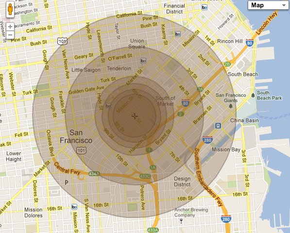
Of course, I immediately wanted to know what kind of damage this could do to San Francisco and found one disturbingly addictive website (for the paranoid) that allows users to see just how much of their hometown could be destroyed in a nuclear blast, overlaid on a Google Map (image above).
According to the website, nearly all of downtown South of Market (the home of TechCrunch’s San Francisco office) would be taken out, and parts of Lower Haight and the Mission would suffer extraordinary damage. Nearly all of San Francisco and parts of Oakland (not shown above) are within glass-shattering range. We pasted the explanation for what each concentric circle represents:
- 1st-2nd: Complete destruction of reinforced concrete structures, such as skyscrapers, will occur within this ring.
- 3rd: Severe damage to complete destruction of reinforced concrete structures, such as skyscrapers, will occur within this ring.
- 4th: Complete destruction of ordinary houses, and moderate to severe damage to reinforced concrete structures, will occur within this ring.
- 5th: Severe damage to ordinary houses, and light to moderate damage to reinforced concrete structures, will occur within this ring.
- 6th: Light damage to all structures, and light to moderate damage to ordinary houses, will occur within this ring.
There is a big caveat: North Korea has an embarrassingly bad missile program. Last year, one of their test rockets fell apart moments after liftoff. So, while there are long-range missiles that could potentially reach the West Coast, I’m not buying a bunker anytime soon.
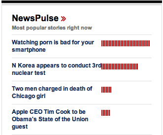
Indeed, many seem to be far less concerned than we might imagine. As of this writing, CNN’s readers appeared to be more concerned about the porn on their smartphones than the threat of nuclear annihilation (at least for a few hours after the news was announced). Below is an actual photo of the relative traffic for their most popular stories.
I’m not sure which is more scary: the fact that we still live in an age when the world can be blown to bits, or that the masses care more about porn on their phones.