Dive Into The Five Great Lakes With Google Earth
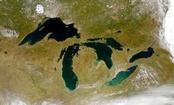

Through a cooperative effort with the NOAA Great Lakes Environmental Research Laboratory (GLERL) and the NOAA National Geophysical Data Center, Google Earth now incorporates detailed bathymetry for the five Great Lakes. Users will be able to explore features such as the canyons and shoals in eastern Lake Superior, the Lake Michigan mid-lake reef complex, and the old river channel, now underwater, that once connected Lakes Michigan and Huron at the Straits of Mackinac.
The NOAA Great Lakes Environmental Research Laboratory has assembled a narrated Google Earth tour, which you can download here. Or you can just check out the Google Gadget embedded in the blog post announcing the addition of the Great Lakes to Google Earth (requires the Google Earth API).
Let us know if you find the lost City of Atlantis in those lakes somewhere.