Sometimes, to move fast you don’t need to break things — you just need to acquire them. So it is with Nuview, a startup aiming to map the world from space using lidar, which announced today its acquisition of analytics platform Astraea.
The terms of the deal were not disclosed. In a recent interview, Nuview CEO Clint Graumann also declined to specify how many of Astraea’s employee’s would be joining the company.
Nuview is relatively young to be executing on an acquisition; Graumann founded the company in January 2022, and has raised at least $15 million to date. But Graumann said that in his experience, companies that try to build out every segment of the Earth observation market on their own encounter issues.
“I’ve always seen Earth observation companies who try to build every capability from the ground up, struggle,” he said. “We build where we have to, we partner where we can, and I think that’s made all the difference in the successful companies throughout the recent history of Earth observation.”
Through the acquisition, he said that Nuview can start executing on its plan to provide intelligence on a wide variety of satellite, aerial and drone data “years faster than we ever imagined.”
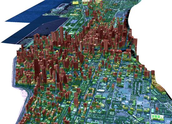
Nuview is aiming to deploy a constellation of 20 commercial satellites outfitted with a lidar system, to map the entire land surface of the Earth on an annual basis. Historically, lidar systems have been heavy and power-hungry, making it ill-suited as a remote sensing technology that could be deployed at scale. But Nuview says it’s developing a proprietary sensor that has lower size and weight, and will be capable of scanning much larger areas at once.
The company is planning on launching a proof of concept satellite called “Mr. Spoc,” though Graumann declined to specify whether Nuview had booked a firm launch date for that demonstration mission. Once the tech is proven out in space, Nuview’s plan is to launch the constellation in tranches of five every 12-18 months, which leaves time to iterate on the technology. The company could even adapt future satellites if there are different resolution or spectral requirements in the lidar being used, Graumann said.
“We also really look forward to finding for example, the altitude with Mr. Spoc, that’s nominal for the constellation that most closely fits customer needs. All of those things combined give us a sense of agility and the capability to improve, to meet broader customer needs or solve more specific problems along the way.”