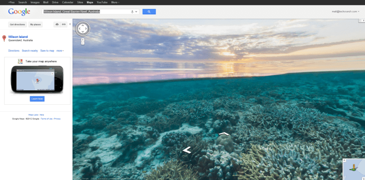
Thanks to a partnership with The Catlin Seaview Survey, Google Maps now displays StreetView-ish images of the Great Barrier Reef and popular underwater spots around Hawaii and the Philippines. Clear your calendar. Forward your emails. It’s time for an undersea adventure.
As Google explained in a blog post today you can now use Google Maps to swim with a turtle, follow a manta ray or lose yourself watching the sun set over a reef. You can go diving in Maui’s Molokini crater or join snorkelers in Oahu’s Hanauma Bay. And of course all this is possible without swim lessons or sunscreen, thanks to the magic of Google Maps.
 The video below shows how the amazing imagery was captured. Using a special one-off camera called the SVII, divers for The Catlin Seaview Survey swam at 4 kilometers an hour to capture the stunning footage.
Right now the imagery is very limited. Outside of the links above, it’s rather difficult to find an area to go swimming. Seaview spots are marked with an orange circle that’s only revealed when the Street View icon is dragged onto the map. Even then, these spots only show up when the map is zoomed in nearly all the way. It seems Google announced this service a bit prematurely.
Google pulled the announcement post shortly after it went live but later reposted everything. Several of the outbound links — to maps.google.com/ocean and The Catlin Seaview Survey — did not resolve at the time of this article’s posting.
But the data is still in the maps right now. You can still leave your cubicle behind and explore ancient boulder coral at Apo Island within a Philippines marine reserve. Who needs a vacation when you have Google Maps?