As we hinted at time and time again, Google has released its native Maps app for iOS…before Christmas. The timing couldn’t come soon enough, as many people have become frustrated with the built-in iOS 6 Maps that Apple offers. Even Apple’s own CEO took it upon himself to apologize for the not-so-polished product, a stand-up act which I actually applauded.
Today is about Google Maps, though. The company has spent the past seven years refining its offering, making its internal systems run quickly to keep up with as many detours, traffic conditions and new apartment complexes that it can. All of that hard work paid off with this app. It’s absolutely gorgeous, runs as smooth as a videogame and is a complete user experience overhaul from any Google Maps experience you’ve ever had. The new swipe gestures to bring up menus, as well as the great detail in which information is displayed, are clear as soon as you open the app. Good thing, because 50 percent of the Google Maps usage comes from mobile devices, obviously.
Now here’s the bad news on this version of Google Maps: there are no biking directions; offline mode (although as soon as you get a route, it is cached on your device), indoor maps; or offers as of yet. This would seem to be incomplete, but clearly the team wanted to put together a fantastic Maps app that serves the needs of iOS users right now. Yes, Google didn’t want to pack everything in too tightly until the world had a chance to play with it. Fair enough, but some of these things would have been nice.
But yes, overall, it’s that good. I took it for a spin yesterday and was able to figure out its new UI immediately. Basically, the map is the UI. All of the menus are neatly tucked away, pulled up and out with gestures that are masterfully designed for iOS. If Apple had only waited a bit longer, this could have been the experience that shipped with iOS 6. It also includes a brand new SDK so that developers can start integrating it into their apps.
I spoke with Daniel Graf, director of Google Maps for mobile, and while he said that Google didn’t hold out as long as it possibly could to release this, I would say that waiting until Apple’s infamous Holiday App Store freeze says otherwise. Even Google won’t turn down a chance to be on all of those shiny new gifted devices.
Here’s what you’ve been waiting for
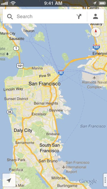
As I mentioned, the UI is unlike what you saw previous to iOS 6, which used Google Maps exclusively. It’s also nothing like you’ve seen on Android, either. The team really hunkered down and pushed out something that utilizes all of the available design elements and gestures built into iOS. Since the app is built on OpenGL, it’s extremely snappy.
“It’s been an interesting half year,” Graf told me, clearly referring to Apple’s decision to go out on its own when it comes to maps.
The result? A completely new app from scratch with a progressive user experience:
You’re not going to see any menu here, the map is the UI. The map is completely vector based, very fast, and we have the search box on top. Those are the two things Google is familiar with, speed and search. Panning around is super fast, labels appear quickly. You Zoom in, you can pan down with gestures for 3D.

Another nice feature is that you don’t have to tap on small location pins anymore to get information. All you have to do is swipe through a new feature for Maps called the “info sheet.”
The info sheet
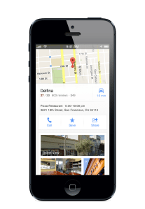 Swiping up from the bottom of the app brings up an “info sheet” that displays information brought in from Google+ Local. You can still see the map while the info sheet is up, which makes navigating from place to place a snap. Say you want to check out a few bars. Simply swipe through some of the suggestions based on the search you just performed.
There’s a “look around” mode that shows photos that people have taken, as well as 3D modeling inside of venues. Those things, seemingly very graphic intensive, load quick as hell. You’ll also find reviews that people have submitted via Google+ Local, which is now tied into Zagat. It’s pretty comprehensive, and could even get a bit social, even though Google+ isn’t fully integrated yet. I think that it will follow pretty quickly, though.
Navigation
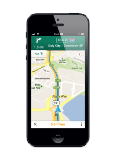 Once you find a place that you want to go to, and sadly this doesn’t include air travel yet, another one of those things that Google simply must include in a future version, you pick your location, pick your starting point, and then you see all of your options. All of the routes are of course dependent upon current real-time traffic conditions, so you might find that you should take a way to work that you’ve never taken before. It takes trust, but once you use the app a little bit, it should come naturally.
This is all voice guided, turn-by-turn, much like you’d find on Android devices using the Navigation app. It’s Siri-like, yes, but the voice will be familiar to you from Google Now. At the bottom of the route, while travelling, simply tap the time and miles to cycle through to see where you are on your trip, something that’s difficult to do in iOS 6 Maps right now. Basically, I’ve found that you have to start your route all over to see an updated destination time.
Tap the three dots on the right to bring up routing information, such as list view, or simply do a two fingered swipe to the left.
Here’s a quick look of how smooth the navigation is from picking a destination to actually starting your trip, and it’s true to life:
Public Transportation and Walking Directions
The thing that bugged me, and others, the most about iOS 6 Maps is that they dropped native support for transit directions. Basically, Apple decided to give you the opportunity to download other apps from developers who were focused on tackling that problem. But there have been no stand-out apps to date that really nail the experience that Google’s version of Apple Maps gave us pre-iOS 6.
Graf told me:
Google covers over a million transit spots in the world. If you’re close to your destination, the app will recommend that you should just walk, or you can take the train if you want to, with pricing shown. You can swipe through different alternatives at the bottom, and bring up the details. We show you the stop lines for public transit.
This means you won’t have to have multiple apps open, along with a web browser, trying to cobble together when your train will come, and how many stops you have till you get off. This is helpful if you’re trying to make sure you don’t get on a bullet train or a bus that skips stops. This has happened to me, and I had to get off and back on the other way. It’s annoying.
Walking directions are solid from what I could tell, something that is key if you live in a dense city, like New York or San Francisco. I’ve found that iOS 6 Maps gets very confused when I’m walking amongst buildings, underpasses, and pretty much anywhere that has multiple levels or close blocks. It just sucks.
Here’s an “in the wild” demo:
What took so long?
I asked Graf a few questions about the app itself and why it felt like it took a while to see the light of day:
TechCrunch: How long have you been working on this app?
Daniel Graf: Longer than you can imagine. The reason is that a mapping app is not a regular app with displays and images. It’s like a game, its OpenGSL. There’s a huge team here. We worked on it for quite a while. In terms of timing, there wasn’t any plan, to wait a bit. We wanted to get it ready, the team worked day and night and we want to give our users the best experience possible.
User experience was the hardest thing in making the app, and the most important. It solves a lot of use cases, and we didn’t want to add just another menu button.
TechCrunch: How does Google feel about Apple now allowing another Maps app to be the default and Safari clicks not opening up Google Maps?
Daniel Graf: We want our native Chrome and Search apps to give you the opportunity to jump into Google Maps. With our new SDK, this is up to the developers to integrate into their apps if they like. Safari is out of our control.
———
Is the app absolutely perfect? No. Nothing is. But when you think about just how much data Google has at its disposal and then think about how fast it’s being transferred to your device over 3G, LTE or Wi-Fi, then you can see just how impressive this first stab at the Maps app is. Is it better than Apple’s current offering? Absolutely. That doesn’t mean that Apple isn’t continuing to work on its own product, though. It will take some time to catch up, especially after this release. Especially since Graf tells me that the mobile team plans to iterate quickly, meaning that we could potentially see an update sometime after the New Year.
If you have feedback on a traffic route or the app itself, simply shake the app no matter where you are in it and the feedback window comes up. It even takes a screenshot of where you are so that Google can have context along with your feedback or traffic routing suggestions. You’ll notice that it has the Google sync functionality that will save your last Maps search on your desktop when you’re logged in. It’s handy when you’re running out the door, a situation where I’ve had to email myself a link to directions or the address I’m going to.
Many thought that Apple wouldn’t approve a Google-branded native iOS app for Maps for competitive reasons. That’s clearly not the case, and never was the case. What is true though is that for some, it’s time to finally update their iPhone to iOS 6.
Update: The app is still propagating on the App Store and some are experiencing errors.
Update 2: You can download it with no problem now.