Any one who commutes in major cities knows the value of back roads when it comes to avoiding traffic on the highways during peak rush hour times. Google Maps just added a nifty feature that will show you live traffic conditions on arterial roads (non-highway roads) in selected cities. Google Maps will also show traffic patterns on main highways as well, helping you see what the least-trafficked route is for your commute.
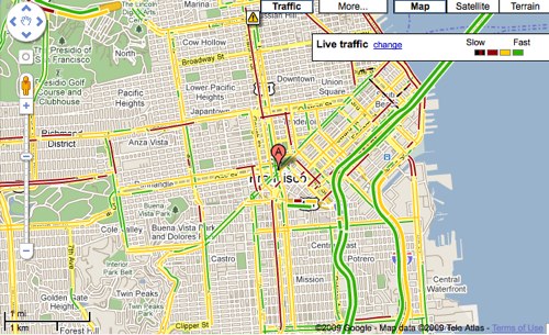
When you zoom-in on the city you’re interested in and click the “Traffic” button in the upper-right corner of the map, you’ll see the traffic conditions of both arterial roads and highways. The colors correspond to the speed of traffic green is little to no traffic, yellow is medium congestion, red is heavy congestion, and red/black is stop-and-go traffic.
Google says that this feature can also be accessed on Google Maps for Mobile, which is particularly useful when trying to figure out the best route on the go. Google also shed a little bit of light as to how they crowdsource traffic info via Google Maps on mobile phones. When you enable Google Maps with My Location, the phone sends anonymous bits of data back to Google describing how fast you’re moving. When Google combines your speed with the speed of other phones on the road, across thousands of phones moving around a city at any given time, they can get an idea of traffic live conditions. They continuously combine this data and send it back to you for free in the Google Maps traffic layers.
Google assures users that they only use anonymous speed and location information to calculate traffic conditions, and only do so when the user has opted to enable location services on his or her phone.