Imaging is one of the key markets in the emerging space tech industry, and for good reason — there’s a proven and robust demand for imaging and Earth observation data among government, private and other clients. Orbital satellites satisfy some of this demand, and companies like Planet have grown sizeable businesses on building satellites that can provide this kind of data more affordably. But startup Near Space Labs is taking a different approach that provides imaging better suited to certain types of industries and uses.
“We decided to start a company and approach this from a totally new angle, and utilize this gap in aerospace, which is the stratosphere — twice higher than where airliners fly,” said Near Space Labs CEO Rema Matevosyan in an interview. “So from that vantage point, we have a very nice view of a very large area, we still can be very high resolution like an airplane or a drone would be, and we can also be very frequent: Currently, we have a daily cadence of imagery, which is unprecedented in this industry at the resolutions that we provide.”
This kind of data is very useful for insurance, real estate and logistics companies, as well as for local municipalities, because it can provide highly relevant and timely data, in the form of very detailed images, quickly. That means you can check progress on a large construction project from an overall perspective, monitor emerging traffic congestion issues or check operational efficiency at a port from a top-down view. Traditional satellites aren’t great at providing this easily and affordably to businesses of all sizes, either, because high-resolution optics from that altitude require hugely expensive spacecraft to operate, or because the younger companies working with more affordable satellites can’t achieve the resolution needed from that operating height, or provide data that’s as timely or available on an on-demand basis.
“Our platform is made to be scalable, and it’s made to be easy to launch in areas where people need it,” Matevosyan said. “And that’s an advantage that we have against solutions that aren’t able to be very reactive to say, a disaster. We can easily fly during and after wildfires for example, whereas others [like drones and airplanes] would have a hard time.”
Matevosyan says Near Space Labs can deploy one of its weather balloon-based stratospheric imaging platforms every day, after which it’ll ascend to its operating height and focus on an area taking photographs while aloft for a couple of hours, then come back down and provide immediate access to the resulting high-resolution images. Near Space Labs has developed its own hardware and software in-house, resulting in a proprietary robotic platform that gathers the data it then provides to clients.
In addition to data, Near Space is working on building analytics layers for the photography it gathers to provide its customers with more of a one-stop shop for both imaging and interpretation.
Near Space Labs has investment from Draper Associates, Wireframe Ventures and the Urban-X accelerator run by automaker Mini. Urban-X is focused on companies that help alter the shape of urban living, and Matevosyan says they see very big opportunities in helping municipalities reimagine how their cities operate, given the type and immediacy of imaging they can provide.
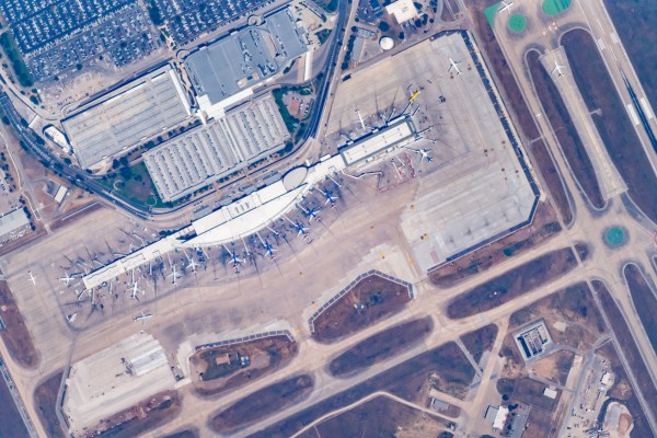
Check out this high-res, 33MB version of the featured image above for an idea of how much detail Near Space Labs can capture:
