CityStream from Nexar harnesses the company’s dashcam app and allows municipalities to make use of the crowdsourced data. The idea is to share traffic patterns and behaviors so that cities can tweak routing and make infrastructure changes based on how cars are actually using roads day to day.
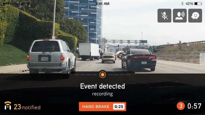
The basis for CityStream is Nexar’s app for iOS and Android that turns your smartphone into a smart dashcam. It records events when danger is detected, like if you hit the brakes hard to avoid another car, and sends the video to the cloud. The phone logs data from the sensors as well to create a picture of what exactly happened with your car when the incident occurred.
The app was already sharing that information among users to help them avoid accidents. Now it’s sharing that data with cities, which is far less expensive for local agencies than buying and deploying a fleet of dedicated vehicles outfitted with sensors. A fleet of Nexar users are already on the streets uploading incidents with their phones.
Cities can use the data to manage areas of congested traffic, route first response vehicles through the path of least resistance, and make the best use of parking and public transportation options. Nexar says that its app can provide an “x-ray” of a city at any time, providing data that can save time and potentially lives. CityStream can also help fleet operators with deliveries to make or ride-sharing companies with effective routing.
The tricky part is that Nexar’s app uses AI to judge the driving of those around you. If a car cuts you off Monday morning, it will recognize that car on Tuesday morning’s commute and warn you to be careful. It’ll warn everyone else of that car too; that’s Nexar’s magic AI-plus-cloud sauce. The privacy implications of this are already sketchy, if technically legal, so sharing this information with the local municipality could possibly result in less than Utopian uses of the data.