Since President Trump took office, there have been protests large and small across the United States and around the globe. Esri, the big-data collection and analysis company, has helped communities using its services plan for these large-scale events and adapt when things don’t go as planned.
“Whenever there’s a march or a disruption, there’s lots of factors to take into consideration across the community to minimize disruption and allow critical services and keep everyone safe,” said Chris McIntosh at Esri. If protesters are blocking a section of downtown streets, which routes can ambulances use to get where they need to go quickly and safely? Will it affect trash pick-up routes that day? Or school buses? “If you throw a rock into a pond, the ripples flow out,” McIntosh said.
Esri takes the location as a framework and uses the context of that location to figure out what an event’s impact is going to be on a community. For example, how many people do organizers expect to show up for an event? Can the park where they’re planning to meet hold that many people, or will they spill into nearby streets?
McIntosh says Esri specializes in “the science of where” — not just where things are, but what it means to the people, the government and the services in an area. “That’s what allows you to effectively manage these kinds of events,” he said in a phone interview.
This includes transit. “When you have people coming in for any gathering — the Boston Marathon or a protest march in downtown Portland — transit has to deal with demand,” McIntosh said. “You may need to up the number of buses on this line or provide crowd control in subway stations.” Managing the movement of people in and out of the area is critical to a peaceful and successful event.
Getting that information out via Waze or other apps to other people not part of the event, who might be commuting or shopping, helps as well. A city’s command center can tell anyone not at the event to avoid a street that’s being blocked by protesters or used for a race. It also can suggest alternative routes. “We can share that data very, very easily,” McIntosh said.
The sticking point isn’t the technology — “That’s the easy part,” McIntosh said. It’s getting all of a community’s agencies on board before the permit for a protest comes across someone’s desk. Agencies have to know who is receiving what data and who shares information with whom. “That has to be done in advance on a blue-sky day,” McIntosh said.
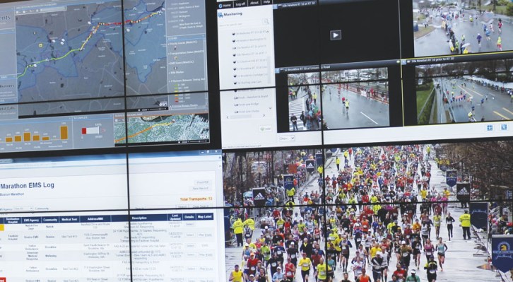
He noted that Boston is a good example of planning. Since they already use data to coordinate for the Boston Marathon every year, they were able to adjust for the New England Patriots’ victory parade after Super Bowl LI pretty easily. “The work they do 364 days a year for the marathon was leveraged for the parade — or for anything else that comes along,” McIntosh said.
He said cities like Boston and Washington, DC that use data to manage their everyday functions are better off when a large-scale event occurs, even if it’s larger than expected. “Understanding context every day sets them up for success when a protest comes up,” he said.