
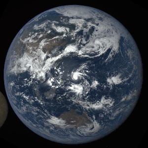
Last year around this time, NASA released the first image of Earth taken by the EPIC camera on the DSCOVR satellite. Since then, that camera has captured a full year of our planet from its location at Lagrange Point 1 about one million miles away.
Compiling over 3,000 images, NASA put together a video showing a sunlit Earth age one full year.
EPIC takes at least one set of images every two hours. Even with this sporadic view of the Earth, footage from EPIC reveals clouds moving across the globe and large weather patterns swirling across the sky. Each set of images is recorded in ten different wavelengths. The wavelengths red, green, and blue were combined to create the color that you see in the video.
Within one short year, EPIC has already seen a variety of interesting events.
A Total Solar Eclipse

Series of EPIC images showing the moon’s shadow move across the Earth during a total solar eclipse / Images courtesy of NASA/NOA
In March, EPIC captured a total solar eclipse, showing the moon’s shadow move across the face of the Earth. Those on Earth who were located in the path of the shadow were able to see a total solar eclipse.
During a solar eclipse, our moon passes between the Earth and the sun. From our Earthly perspective, we look up in the sky and see a sun eclipsed, darkened by a circular shadow, for a brief period of time.
Lunar Transit

Series of EPIC images showing the lunar transit that took place in July, 2015 / Images courtesy of NASA/NOAA
Because of DSCOVR’s unique position, it witnesses one or two lunar transits each year.
Since DSCOVR is located between the Earth and the sun at all times, and the moon orbits around the Earth, intuition may lead you to believe that you should always be able to see the moon from DSCOVR’s perspective. But because EPIC has a very small field of view, the moon is incredibly far from Earth (see scale below), and the moon’s orbit is tilted about five degrees, it’s usually outside the frame of view.

Distance between the Earth and the moon to scale / Screenshot from BuzzFeed video “209 Seconds That Will Make You Question Your Entire Existence”
The first lunar transit was witnessed on July 16th, 2015 and the second lunar photobomb occurred July 4th of this year.
Series of EPIC images showing the second lunar transit that took place July, 2016 / Images courtesy of NASA/NOAA
Weather and the Poles
[gallery size="tc-article-featured-image-wide" ids="1357817,1357816,1357819,1357818"]
In addition to total solar eclipses and lunar transits, EPIC has seen a trio of large storms marching across the Pacific Ocean (first image), forest fires in Southeast Asia (second image), as well of views of the North and South poles (third and fourth images).
EPIC’s ability to view both the North and the South poles over the course of a year is due to Earth’s tilt. This is the same reason we experience seasons throughout the year.
When we see the North pole tilted toward EPIC, that means it’s also tilted toward the sun and the northern hemisphere is experiencing summer. Similarly, when the South pole is tilted toward EPIC, that means those in the southern hemisphere are experiencing summer.
EPIC Science
EPIC is an Earth Science instrument on board the DSCOVR satellite, a National Oceanic and Atmospheric Administration mission, which launched in February, 2015. The spacecraft always remains between the sun and the Earth at a special gravitational balance point called Lagrange Point 1. At this location, DSCOVR is “parked” between the Earth and the sun at all times, allowing for it to make observations of an Earth-facing sun and a sun-facing Earth at all times.
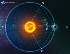
DSCOVR location in relation to the Earth and sun / Image courtesy of NOAA
From DSCOVR’s vantage point, scientists can study cloud cover and weather patterns throughout the year. EPIC’s spectral images will enable the measurement of ozone amounts, aerosol amounts, cloud height and phase, vegetation properties, hotspot land properties and UV radiation estimates at Earth’s surface.
Altogether, these images provide a constant view of our planet that we’ve never really had before. With DSCOVR’s mission life set at five years, we can expect more sunlit global images coming our way from EPIC for at least the next few years.