Flying a drone is kind of like driving a car that only has a windshield. You can only look in one direction at a time, and when the drone gets out of visual range, the user is left with a single view through the lens of a camera. Hivemapper, a company that just raised a $3 million Series A led by Spark Capital, is looking to make that a bit safer.
You can think of Hivemapper as a Waze for drones.
Hivemapper has mapped over 20 million building boundaries, more than 10 million building heights, and 15 million points of interest all plotted on a 3D map. Plus, the app has mapped tens of thousands of no-fly zones across the country.
As Hivemapper continues aggregating its own data about buildings and obstructions, users are also encouraged to report issues with areas as they’re happening, as well as interesting routes and launch points across their community.
The app is compatible with the DJI Phantom 3, Phantom 2, and Inspire 1, and is currently running on Android with the iOS version in beta.
Users will be able to fly through the app with those compatible drones and get alerts for nearby buildings or obstructions in real time.
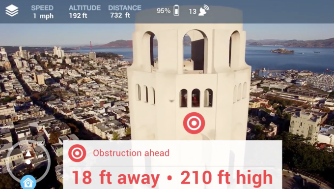
When asked about the business model, Hivemapper founder Ariel Seidman said they are focused fully on product that delivers a fun, save and productive flight.
“Once we are successful in that realm we can imagine other businesses in the drone ecosystem will want to embed Hivemapper as an ingredient, as many do today with Google Maps, into their products and services,” he said.
You can check out how Hivemapper works in the video below.