
If you’ve spent much time in San Francisco over the past few years, you’ve seen the city slowly congest itself into something Gordian. Getting around has become increasingly difficult as construction cuts into lanes, roads can’t handle the traffic load, and the public transit system strains to operate in an increasingly chaotic environment.
The issue is bad enough that I’ve started to patch together various forms of transportation to do my job. Oftentimes, getting to a meeting is a faster proposition on foot than in a car. The issue is when you aren’t sure what method of transit is fastest right now.
Enter Urban Engines‘ work to bring what it calls ‘mixed-mode routing’ to the public. Out this week on both iOS and Android, Urban Engines updated app is a tool to help you figure out the fastest way to get to your destination. The app can handle walking, driving, public transit, and Uber. With Uber, Urban Engines will show you the expected cost of a car from the ridesharing service, alongside other options.
The mixed-mode transit tool works in around 50 North American cities. Presumably that figure will grow throughout the year. Still, for a first launch, the geographical reach of the firm feels sufficient.
The app looks like this in practice:
[gallery ids="1169347,1169348,1169349,1169350"]
Why in the flying fuck do we need another mapping tool? Because as it turns out there is ample space in the market category to try new things.
Urban Engines includes the ability to download full cities, so that you don’t have to depend on cell coverage when traveling to get around, for example. That feature will matter more as the company expands its coverage of international locales.
But most importantly, the app contains an ‘x-ray’ like feature that maps the world’s roads and so forth directly onto your phone view so that you can see where to go from where you stand. Here’s what it looks like in practice:
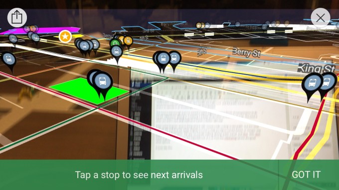
This helps as, if you are like me, you never know which way to turn to start your transit. With the above feature, you can quite literally map the app onto your world and thus be given directions that change based on where you are standing. It’s quick, and surprisingly compelling.
It’s interesting to see how transit directions remain a place where even the large players are catching up. Apple, yesterday, announced that transit directions are coming to its Maps apps in iOS. Given that Apple’s news dropped in near conjunction with Urban Engines’ release, I asked the firm about the other company’s release. Here’s what the startup told me:
“While Apple has long led the market when it comes to mobile design and user experience, maps has been something of a chink in its armor. It’s hard enough to build mapping systems from the ground up, but for Apple, the burden is even higher having to integrate disparate data and legacy systems. The promised mapping updates we’ve seen from both Google and Apple in the last two weeks are a clear recognition that the needs of the modern urban commuter have changed, and now they are playing catch up. At Urban Engines we identified these needs early on and have been laser-focused on reimagining the mobile map experience for today’s urban commuter.”