 At first glance, Blue Water Satellite might strike you as a poor fit for a post on this website. We’re so inundated with web-based startups that we forget there is a world out there full of technology startups that are just as new and just as interesting, but have nothing whatever to do with the web. But in addition to being an interesting business in its own right, Blue Water Satellite is an example of the deep data analysis industry which in a way has always been with us, but more recently has been flourishing due to the sheer volume of useful data.
At Disrupt we saw an impressive toolset for social data provided by DataSift. Those guys surely have a rosy future if only because they’re getting in early to the web data-diving game. Similarly, Blue Water Satellite (BWS) has a very specific mission at the moment, but the way they’re branching out, they hope to be a leader in the growing business of satellite and environmental data analysis. Providing a unique and powerful way to visualize or interpret a huge amount of data is turning into quite the business model.
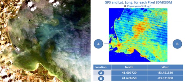
The core concept at BWS is detection of cyanobacteria. It’s a microorganism found all over the world, and which can be dangerous above certain (disputed) concentrations. A pigment found in these creatures, phycocyanin, makes them susceptible to satellite surveillance, but only with the right tools. Traditionally, it’s tested by actual boats dipping into test waters and sending the actual water to an actual lab — a time-consuming process BWS estimates to cost around $300 per data point (that is, per dip), which limits the amount of testing that resource management organizations (think parks departments, the EPA, farmers, industrialists) can or are willing to do. A large lake or series of lakes in a state park might need several launches and a hundred data points several times a year, the costs of which add up for cash-strapped services and nonprofits.
With the aim of improving the entire water monitoring industry (and others), BWS researchers spent two years doing the traditional method, so they could compare it with their own, newer method: by performing a complicated and patented algorithm to raw Landsat imaging data (including, but not exclusive to, visible spectrum), BWS is able to detect cyanobacteria with far greater precision, speed, and range than traditional boat-based methods. It’s a bit like they made a way to Google your lake for the stuff.
It’s also far cheaper: around $0.40 per data point, by their estimate. With that kind of improvement, it seems like only a matter of time before this method is the de facto standard.

I spoke with Milt Baker, Blue Water Satellite’s CEO, about the possibilities and limitations of their business. Coming off reading a number of articles about water scarcity, I asked whether this type of technology was applicable to monitoring municipal watersheds, industrial waste, and so on — things that could be applied internationally to improve the treatment and availability of potable water. Milt said that because the Landsat data is global, and their job is to perform analysis on it, there’s really no geographic limitation to their work. He noted that a lot of governments are under pressure to comply with increasingly stringent water standards, and waste and global warming are causing cyanobacteria and other dangerous elements to spike; the old methods of testing aren’t effective enough.
China, for instance, is approaching a water crisis due to the rapid expansion and ineffective regulation of industrial plants, and chances are they’d see a cost-effective method of outsourcing water testing like this tempting. The scale of the job, too, isn’t an obstacle. He described a job where they had surveyed a 730,000-acre watershed for around 2% of the $500,000 the governing organization had estimated it would cost. That level of savings could be a lifesaver for strapped governments that need to perform due diligence on their water supply, but can’t spare $50 million in yearly operational fees.
The amount of data provided by Landsat (at 16-day increments, going back to the 80s) and in turn, the amount of data BWS can provide to its clients, is formidable. Milt compared this change to the change that occurred when ocean temperature mapping went from ship-based to satellite-based. The amount of information provided, the cost of that information, and the ease of accessibility made for a revolution in environmental science, and Milt hopes something similar will occur with the monitoring of accessible water.
BWS is already capable of detecting phosphorus concentration in land, a useful statistic for agribusiness, and there is R&D going towards detection of animal herds, oil fields, and all the rest of the information hidden in the vasty depths of satellite imagery.
As I said earlier, I find this to be at once a very old and a very new industry. The art of meta-analysis and consulting has been around since the first shamans and chiefs, who used their experience to condense and organize knowledge based on their superior and seasoned understanding. And throughout history it has been incumbent on scholarly authorities to do the kind of obscure analysis that either yields great insights or confirms there were none to be had. Think tanks have lately put powerful minds to work for private money.
Now, the volume and variety of information being produced is so immense that it has become a business model to simply specialize in the extraction of a very specific kind of knowledge from that information. Imagine if Facebook were to make a year’s worth of data on their users available to psychologists, sociologists, and epidemiologists — they would all find different values and trends, all find different ways of making the same set of numbers and characters useful to others.
Raw information is becoming like a natural resource, but one which cannot be depleted, or even reached exactly, but rather must be looked at from different angles, with different lenses. Blue Water Satellite has one very specific lens through which we can view the increasing concentrations of toxic bacteria in our waters due to global warming and other factors. Google might take the same data and put our water sources in context with human infrastructure and cross-correlate population growth, political trends, and traffic data.
Connecting the dots has become a major industry, and the more dots there are, the more there is to connect between them. Hopefully more businesses like BWS will appear and thrive, directed towards increased awareness and knowledge of our planet and social system, and less directed at (as is the current trend) vanity and convenience.
More information can be found at Blue Water Satellite’s website, where you can learn more about cyanobacteria, BWS’s methods, and view a sample report.
