“Burn rates” are perennially on the minds of Silicon Valley VCs and entrepreneurs. But what about the very real burn rates that ravish the surrounding California countryside, and other areas, each year?
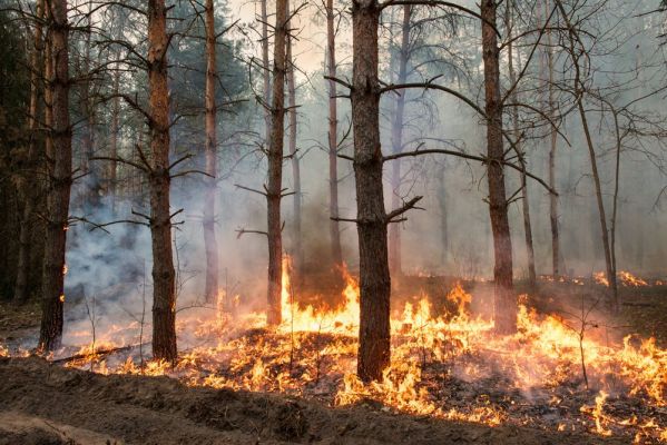
Currently there are five states that are each battling more than 10 major wildfires, with seven million acres burned so far. This is not a flash in the pan (no pun intended). Each year, the situation worsens. The average number of large wildfires occurring annually is up 78 percent since the 1980s. As a result, resources for fighting these fires are badly stretched. In spite of having nearly 29,000 firefighters battling the Western blazes, often at great personal risk, it has not been nearly enough to contain many of the fires. The National Guard has even been called out to augment firefighting staffs.
The trend is not going away. More firefighters and more firefighting equipment are, of course, needed. With the situation seemingly getting worse and not better, how can we turn a losing battle on its head? One way is to apply some of our biggest tech innovations.
Big data is already being used to understand and predict wildfire spread, but how can some of the other big technology trends potentially help?
Game Of Drones
We’re starting with a controversial one, given that Californian wildfire fighters are currently complaining about hobbyists flying drones close to low-flying firefighting aircraft, forcing planes to be grounded, thus causing more countryside to burn. Certainly, drone pilots need to play by the rules and follow FAA guidelines, especially in emergency situations, but what if the power and mobility of drones could be unleashed to fight fires? Those drones are capturing hours of videos, but what is being done with the video and images?
Tracking the status of vegetation (the fuel) and developing conditions is difficult across vast expanses of undeveloped, often inaccessible land. Drones offer tremendous opportunity from the hours of videos and imagery they capture, enabling authorities to spot conditions ripe for wildfires.
What if the power and mobility of drones could be unleashed to fight fires?
More accurate information about conditions on the ground leads to better situational awareness for county fire departments, and will help improve the modelling which facilitates the identification of risk early enough to take action. Getting a complete aerial picture cost-effectively and without endangering humans could increase the efficacy of preemptive burning, reducing the impact to lives and property.
Further into the future, artificial intelligence playing a larger role to fight fires on the ground will become commonplace. The complexity of navigating varied and often hazardous terrain is not an insignificant one for roboticists, but it is one that’s already been tackled for military applications, such as bomb sniffing and searching caves for terrorists. It is not much of a stretch to believe that such technologies will soon help in the battle to prevent and contain wildfires.
A Gold Star For Machine Learning
With the images and videos captured by drones and also by strategically placed cameras on the ground, FEMA and fire departments can now step beyond GIS/mapping techniques, which are purely dependent on manual updates. Machine learning innovation is powering highly advanced, automatic object recognition that can identify in seconds patterns that take human analysts hours to search and chart out on a map (even with advanced GIS software).
The technology already exists to take vast repositories of videos and imagery and pull out the proverbial needle in a haystack. It’s the same visual search technology that’s being used by security agencies and law enforcement to spot imminent threats and locate dangerous suspects. It’s being used by sportswear brands to see how often their logo is used in sponsorships. It’s not a giant leap to teach these systems how to spot patterns and conditions from images of vegetation that commonly lead to a fire breaking out or spreading rapidly.
Internet Of (Wild) Things
Deploying sensors on specially designed networks to monitor conditions, detect changes early and predict outcomes can provide an even richer data set than aerial monitoring.
The challenges are immense, given the sheer number of sensors needed and the vast expanses of land to cover, but this idea has been successfully trialed in Europe. Furthermore, there are existing networks in place that make for a good starting point. Researchers at UCSD have been able to leverage existing sensors deployed within forests by fire stations to supplement an array of other data and create real-time analytics systems.
Smokey Bear And Social Media
Crowdsourced information pulled from social media has been seen as a helpful tool to identifying the spread of wildfires and helping to deploy forces. Monitoring social posts for mentions or pictures of fire or smoke from at-risk locations could be an important data stream, thus creating an early warning system when wildfires start or spread. This could become particularly useful, given the increasing number of people choosing to live in and around the periphery of at-risk land.
We humans are the weakest link in the chain, causing 9 out of 10 wildfires.
However, social media’s greatest contribution could come in the form of the advanced targeting it offers to advertisers. For more than 70 years, Smokey Bear has been successfully educating outdoorsy Americans on how to prevent forest fires. That’s important because, as we all know, we humans are the weakest link in the chain, causing 9 out of 10 wildfires.
Authorities can now target location-savvy PSAs (public service announcements)/educational ads to social media users along the periphery of at-risk areas using geo targeting, raising awareness and hopefully reducing the human risk of starting wildfires. Authorities also could target PSAs based on interests, like to the 20-25 million people on Facebook with an expressed interest in camping. The ability to cost-effectively inform and educate for prevention at scale has never been greater.
If we can apply to the worsening problem of destructive wildfires some of the innovations from the tech sector’s best-funded, exciting and emerging technologies, we may have to opportunity to make a huge difference in prevention, detection and response. And that is no flash in the pan.