As a part-time urban planning nerd, I love visualizations of buses, trains and cars pulsating through cities. Now with more data available through smartphones, emergent logistics platforms like Uber and eventually Internet-connected and self-driving cars, it’s inevitable that software will become indispensable in managing and making mass transit more efficient.
That’s the bet of a Silicon Valley-based startup called Urban Engines that was founded by some very, very longtime former Googlers and a Stanford computer science professor named Balaji Prabhakar. Initially, they built out software to help cities like Singapore and Sao Paulo manage their public transit systems. But now they’re moving forward with a consumer-mapping app that works quickly when you’re offline.
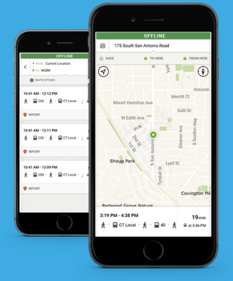
Why, might you ask, would you need an additional mapping app when Google already provides one?
Well, Urban Engines’ app doesn’t rely on mobile Internet when you’re underground in the subway and it also has a few UI flourishes that make the experience faster than the regular Google Maps app. For one, when you boot it up, you don’t have to type in a destination; you can just drag the center of the map to wherever you’re going and it will generate different routes for you automatically.
Urban Engines has created offline maps for 10 different cities in North America, including New York, Boston, Chicago, Los Angeles, San Francisco, Portland, Seattle, Toronto, Vancouver and Washington, D.C.
There’s also an X-ray mode that overlays a map over the streets and helps you figure out where you’re going.
Doing this is harder than it sounds. The 30-person company, which is backed by an undisclosed amount of funding from Eric Schmidt, Google Ventures, Andreessen Horowitz, Ram Shriram, SV Angel and others, has put together its mapping solution from OpenStreetMaps and other sources for public transit data. They’re competing against the 3,000 people who work on Google Maps.
“What we’ve been doing is collecting movement data from connected cars, connected buses, and connected trains,” said Prabhakar. “Commuting today is multi-modal. You have to put together this jigsaw puzzle of mobility from many different sources.”