Modea, a digital advertising agency focused on design and technology, claims not only to help its clients build their brands (and advertise) but also to “make and design things they would use themselves”. While this is always a good litmus for a new product or business, you’ll have to excuse my cynicism, but coming from an advertising agency, statements like these are questionable. But, that being said, it’s great to see that Modea is an agency that builds products and apps, tinkering right alongside the companies whose brands they help to hawk. What’s more, they’ve built something today, called InstaEarth, that Instagrammers may very well find usable themselves.
Instagram is fairly popular these days; the app hit 5 million users back in June and have been adding 625,000 users every month since launch. They seem to be doing with four people what Color couldn’t do with $41 million by focusing on providing a killer visual experience for their users. As my colleague MG Siegler made mention of, part of the reason they’ve been able to do this with such a small team is that they’ve focused on the mobile app and API, allowing developers to fill in the holes and help create the rest of the user’s experience.
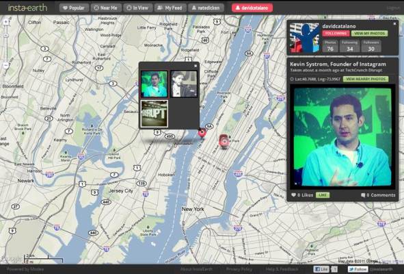
So, if Instagram is an app that allows “users to tell the story of their lives in a visual way”, InstaEarth is an app that visualizes the story of Instagram users worldwide — in map form. And it’s trying to be more than just another Google maps mashup. I’ll let you decide whether they’ve succeeded in this endeavor, but so far, I’m impressed.
But, how in the sam heck does it work? InstaEarth allows you to navigate and explore Instagram photos on a global map layout, showing photos on the map in the location they were taken. (Though, of course, you have to connect the app to your Instagram account for it to have real useful application.) Users can organize the visual experience based on the popularity of the photos, the proximity to their current location, their own photos, photos of friends, etc.
Users can zoom into any location on the map and view photos nearby taken by any other Instagram user, or enjoy the voyeurism inherent to clicking on any Instagram user and then viewing every location in which they’ve taken a photo. Slightly creepy? Maybe. Kinda cool? Yes. Of course, Instagram users have the option in the app’s settings to decide whether or not to share publicly at scale, so if you’re not the sharing type, not to worry.
InstaEarth creators and Modea creative developers Chris Allnutt and Nathan Dicken have been Instagram users since they beginning, they say, and had long wanted to see a feature that allowed a more exploratory dimension to seeing the world through other Instagram users’ eyes. They’re off to a pretty good start, though there are some tweaks needed in the web interface. But so does TechCrunch. The founders said that they have plans to add UI enhancements soon, as well as a slide show view, “official” iPad mobile web support, realtime updates, search, and deeper integration with Google Places API.
Alnutt said that his young son will get up every morning, eager to follow the travels and photography of users around the map. While this may not be the motivation you’re looking for, it is fun to play with, if not to wake up to.
Check it out here and let us know what you think.
