Editor’s Note: This guest post is written by Jon Steinberg who very recently accepted a position an an Executive-In-Residence at Polaris Venture Partners, which backs PublicEarth. Still, this is an interesting product and concept in an interesting space, location, which we will be dealing with during our Realtime CrunchUp event this coming Friday. Other ideas in the vein include GeoAPI and to a lesser extent, SimpleGeo. Previously, Steinberg was a strategic partner development manager for Google’s Small Medium Business team.
 The rapid development of interesting web services can be attributed to the ability of each successive builder to create a layer upon what others have built. The existence of APIs and callable web services means that each builder can add value on top. When you combine this with crowd-sourcing, you effectively pour lighter fluid (in a good way) on this layering process. The only remaining element required is a taxonomy to insure that the crowd-sourcing creates content that is structured enough to make sense despite coming from many hands.
PublicEarth, a Polaris portfolio company that is launching today, takes the power of API layering, crowd-sourcing, and taxonomy and focuses it on maps. PublicEarth describes itself as a wiki of places, specializing in collecting all those “long tail” places that most other databases tend to overlook.
Maps is an area where I think there has been relative underdevelopment relative to importance, especially in light of all the emerging mobile, social, local platforms. Everyone I talk to working in this space needs more local data and detail to power their services, as well as, an open crowd-approach to keeping it up to date and granular as possible.

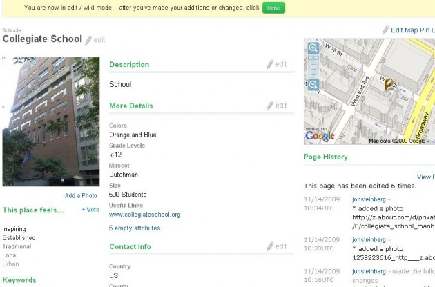
PublicEarth pulls in Google maps, and then applies a customized categorization and set of data fields to each entry. For example, I went to Collegiate School in Manhattan for high school. Rather than just having a one size fits all entry structure that allows for simply “reviews,” PublicEarth applies the fields: colors, grade levels, mascot, and size.
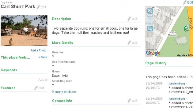
Similarly, for Dog Parks, the site lists whether or not there are benches, pick up bags, and areas for small dogs. Multiply this type of field customization by the seemingly unending quantity of place categories provided by PublicEarth and you have a “wiki for the world.” Notice, also, how on the right side of each place entry is a running log of the changes made by editor users. The site is open and democratic; everything is open for editing and customization by users.

And then these highly customized places can be grouped into sets that you can share across the web. For example, here’s a widget featuring elementary, primary, and extracurricular schools in New York that friends and family I know have attended or taught at. Public Earth is so detailed in its taxonomy that it even has a Culinary School category.
And that use of APIs and layering goes both ways. Public Earth has a detailed API that can be used to both pull content from and push content into the layer. I think being able to push content into Public Earth is of particular importance. There are many stakeholders that want to be able to contribute local map information in individual and bulk fashions to a central wiki-like repository.
Public Earth has already taken feeds from dozens of providers, like CitySearch, Sam’s Club, and SpaFinder, and plans to incorporate many more. So if you want to update information for individual locations, natural attractions, schools, or businesses use the front-end. And if you have a bulk feed of locations you service in some fashion, you can become a content partner to PublicEarth, or just push them through the API.
If you are interested in using the API during this beta period, email the team, email me, or leave a comment on this post and we’ll be sure to get you one. Finally, my big congrats to the PublicEarth team. I think PublicEarth is an important site, and as Mike Hirshland put it “The notion of high value discovery layers over web utilities is a theme in the Polaris portfolio.” What Brizzly is for Twitter, PublicEarth is for Google Maps. You can find my profile and contribution on PublicEarth here.